Aberaeron: A Flood Defence Case Study
Introduction
Aberaeron is a picturesque harbour town on the west coast of Ceredigion, Wales. Situated at the mouth of the River Aeron, the town is exposed to both river and coastal flooding.
As sea levels rise and storms become more frequent and intense, the risk of flooding is expected to increase. To help protect homes, businesses and important infrastructure, a major flood defence scheme was completed around the harbour.
However, protecting the town from flooding has created a new challenge. Changes to coastal processes have contributed to a build-up of sediment at the harbour entrance, affecting access for some harbour users.
This case study explores how attempts to solve one environmental problem can sometimes create new challenges elsewhere.
Understanding the Risk
River Flooding
The River Aeron flows through Aberaeron before reaching the sea through the harbour. During periods of heavy rainfall, water levels in the river can rise rapidly, increasing the risk of flooding in parts of the town.
Coastal Flooding
Aberaeron is exposed to storms from the Irish Sea. During severe weather, large waves, storm surges and high tides can cause coastal flooding and erosion. Climate change and rising sea levels are expected to increase these risks in the future.
Historic Floods
Flooding has affected Aberaeron for many years. In the past, storm waves have overtopped harbour walls and sea defences, while periods of high river flow have also caused flooding. These events have damaged homes, businesses and local infrastructure.
Storm Surge of 2014
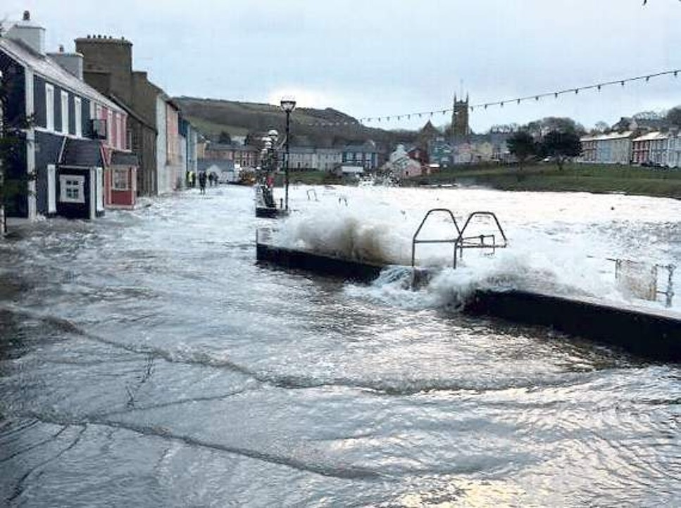
Image: Flooding in Aberaeron following the 2014 storm surge. Source:Cambrian News - accessed August 2026
In January 2014, a storm surge brought sea water over Aberaeron's harbour walls, flooding roads and properties. The event demonstrated how vulnerable the town is to extreme coastal weather.
Storm Callum
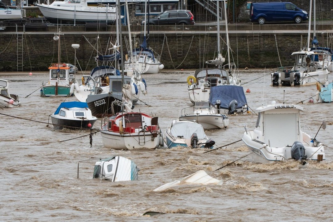
Image: Storm damage to boats in Aberaeron Harbour during Storm Callum (2018). Photograph by Shane Jones. Source: Wales Online - accessed August 2026.
In 2018, Storm Callum generated powerful waves within Aberaeron Harbour, severely damaging and sinking several moored boats. Although this event is best remembered for the damage caused to vessels, it also highlighted the risks posed by extreme weather along the coastline.
Maps
Town Map
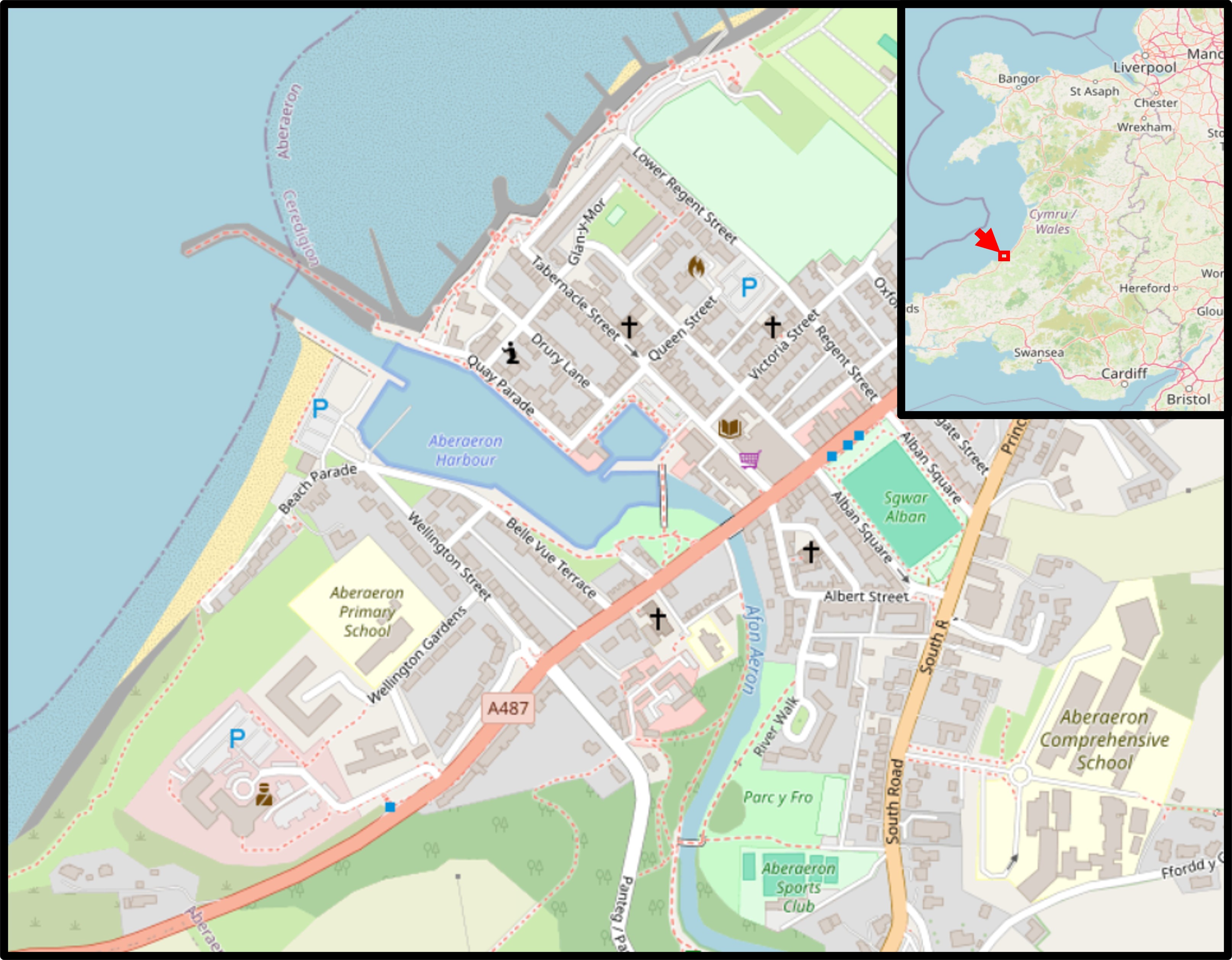
Map: Aberaeron and its location within Wales. Source: OpenStreetMap contributors - accessed August 2026.
Flood Risk
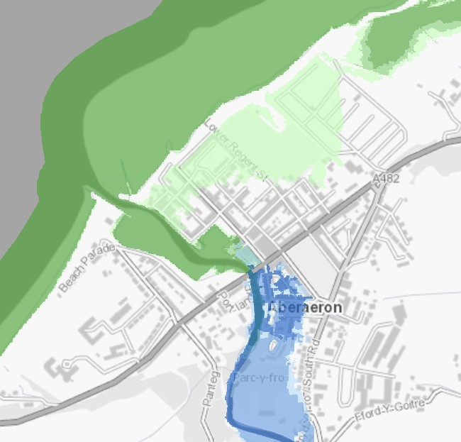
Map: Flood risk in Aberaeron showing areas vulnerable to river and coastal flooding. Source: Natural Resources Wales Flood and Coastal Erosion Risk Maps, using Ordnance Survey data - accessed August 2026.
The above map shows the flood risk areas identified by Natural Resources Wales (in May 2026). Green highlights risk of flooding by the sea, blue for risk of river flooding.
Compare the flood risk map with the town map. Why do you think Aberaeron is vulnerable to both river and coastal flooding?
The Flood Defence Scheme
Aberaeron faces flood risk from both the River Aeron and the Irish Sea. Severe weather can cause flooding from high river levels, storm surges, and large waves entering the harbour. Climate change and rising sea levels are expected to increase these risks in the future.
The Aberaeron Coastal Defence Scheme was developed to reduce the risk of flooding and coastal erosion. The scheme was designed to protect 168 residential properties, while also reducing flood risk to businesses, community facilities and other important assets within the town. It was intended not only to address current flood risks, but also to help Aberaeron adapt to future changes in climate and sea level.
Why now?
While flooding and coastal erosion had been concerns for many years, several factors made action increasingly urgent.
The South Pier
The head of Aberaeron's South Pier had become structurally unsafe and was closed to the public. Engineering studies suggested that if the pier head collapsed, the rest of the structure could follow. The pier played an important role in trapping shingle on South Beach. Without it, large amounts of sediment could be lost, increasing erosion and exposing the town centre to greater wave attack during storms.
Ageing Coastal Defences
The timber groynes and rock revetments protecting South Beach were approaching the end of their working life. Assessments indicated that many of these structures could fail completely within the next one to three years, reducing protection against coastal erosion and leaving the coastline increasingly vulnerable.
Increasing Flood Frequency
Flooding caused by waves overtopping the harbour walls was becoming more common. By the time the scheme was being developed, overtopping events had become approximately a 1-in-5-year occurrence, indicating that flood risk was increasing and that existing defences were becoming less effective.
Together, these factors meant that maintaining the existing defences was no longer considered a sustainable long-term solution. A larger scheme was therefore developed to improve protection against flooding and erosion while preparing Aberaeron for future climate and sea-level changes.
What was built?
To improve Aberaeron's resilience to flooding, a major coastal defence scheme was completed around the harbour and waterfront.
The scheme included:
-
Breakwater
A new breakwater was constructed at the harbour entrance. Its purpose is to reduce the energy of waves entering the harbour during storms, helping to lower the risk of overtopping and flooding within the harbour area.
-
Flood Walls and Flood Gates
New flood walls and flood gates were installed around the harbour. These provide protection during periods of high water levels while maintaining access to the waterfront during normal conditions.
-
Rock Armour and Rock Revetments
Large rocks were placed along vulnerable sections of the coastline to absorb wave energy and reduce coastal erosion. By dissipating the force of incoming waves, these structures help protect both the shoreline and nearby infrastructure.
-
Timber Groynes
Timber groynes were constructed on South Beach to help manage the movement of sediment along the coast. By trapping sand and shingle transported by longshore drift, groynes help maintain beach levels and reduce erosion.
-
Harbour Infrastructure
Sections of harbour infrastructure, including parts of the South Pier, were reconstructed or strengthened as part of the project to improve the long-term resilience of the waterfront.
-
Public Realm Improvements
The scheme also included improvements to public spaces around the harbour. These improvements were designed to work alongside the flood defences while helping to maintain Aberaeron's appearance as a popular harbour town.
If you are unfamiliar with terms such as breakwaters, groynes, rock armour, and flood walls, explore our Sea Defences resource to learn more about the different methods used to manage coastal flooding and erosion.
Costs
The Aberaeron Coastal Defence Scheme cost approximately £31.59 million.
Funding was provided through a partnership between:
- Welsh Government Coastal Risk Management Programme: £26.85 million.
- Ceredigion County Council: £4.74 million.
The Welsh Government's contribution covered more than 85% of the total cost. This made it possible for Ceredigion County Council to undertake a major infrastructure project that would otherwise have placed considerable pressure on local capital budgets and potentially affected other planned investment projects.
Has the Scheme Been Successful?
Reduced Flood Risk
The primary aim of the Aberaeron Coastal Defence Scheme was to reduce the risk of flooding and coastal erosion. The new breakwater, flood walls, flood gates and coastal protection measures have significantly improved the town's ability to withstand severe weather and extreme sea conditions.
The scheme was designed to protect 168 residential properties, as well as businesses, community facilities and infrastructure throughout the town.
Preparing for Climate Change
The scheme was not only designed to address current flood risks, but also future challenges. Rising sea levels and changes in storm frequency are expected to increase flood risk over the coming decades.
By constructing new flood protection measures before existing defences failed, the scheme helps improve Aberaeron's resilience to future coastal hazards.
Protecting a Working Harbour Town
As well as reducing flood risk, the project included improvements to parts of the harbour and waterfront. Engineers faced the challenge of protecting the town while maintaining Aberaeron's role as a working harbour and popular tourist destination.
The scheme was therefore designed to balance flood protection with the needs of residents, businesses and visitors.
A Complex Success Story
From a flood protection perspective, the scheme has largely achieved its primary objective of reducing flood and erosion risk to the town.
However, large engineering projects can have unintended consequences. In the years following construction, concerns were raised about increasing sediment build-up at the harbour entrance, creating new challenges for some harbour users.
This raises an important question:
Can a project be considered successful if it solves one problem but creates another?
A New Challenge
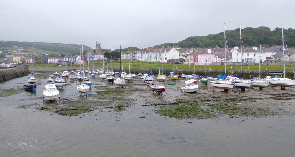
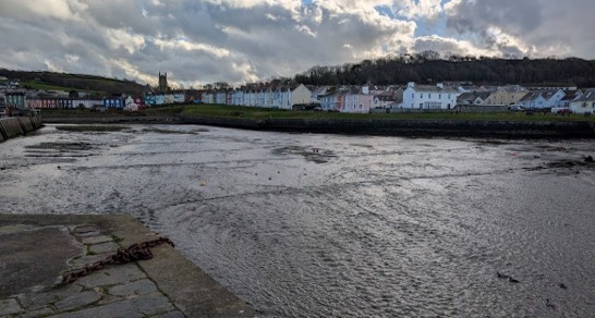
The flood defence scheme was completed in 2025, yet photographs taken the following year show a very different harbour. While the scheme succeeded in reducing flood risk, a new challenge had emerged.
What could have caused this change in harbour usage?
Understanding Longshore Drift
To understand the challenges facing Aberaeron Harbour, we first need to understand how sediment moves along a coastline.
Waves rarely approach the shore in a perfectly straight line. Instead, they often arrive at an angle due to the direction of the prevailing wind. As waves break on the beach, they transport sand and shingle up the shore. Gravity then pulls the material back down the beach at a slightly different angle.
Over time, this process moves sediment along the coastline. This movement is known as longshore drift.
Managing Sediment Movement
Engineers recognised that sediment movement was an important part of the coastal system when designing the Aberaeron Coastal Defence Scheme.
To help manage coastal erosion and sediment transport, the project included:
- Repairs and extension work to the South Pier.
- New timber groynes on South Beach.
- Rock revetments and other coastal protection measures.
These structures help trap sediment close to the shoreline, reducing erosion and helping to maintain beach levels.
However, they can only influence sediment that is moving near the coast.
Aberaeron lies within the wider coastal system of Cardigan Bay, where waves move sand and shingle over large areas. Some sediment may travel further offshore than the groynes can intercept, allowing material to continue moving towards the harbour entrance.
This means that while the groynes help reduce erosion on South Beach, they cannot completely prevent sediment from reaching the harbour.
A Harbour Entrance Under Pressure
Despite efforts to manage sediment movement, large accumulations of sand and shingle have formed near the harbour entrance.
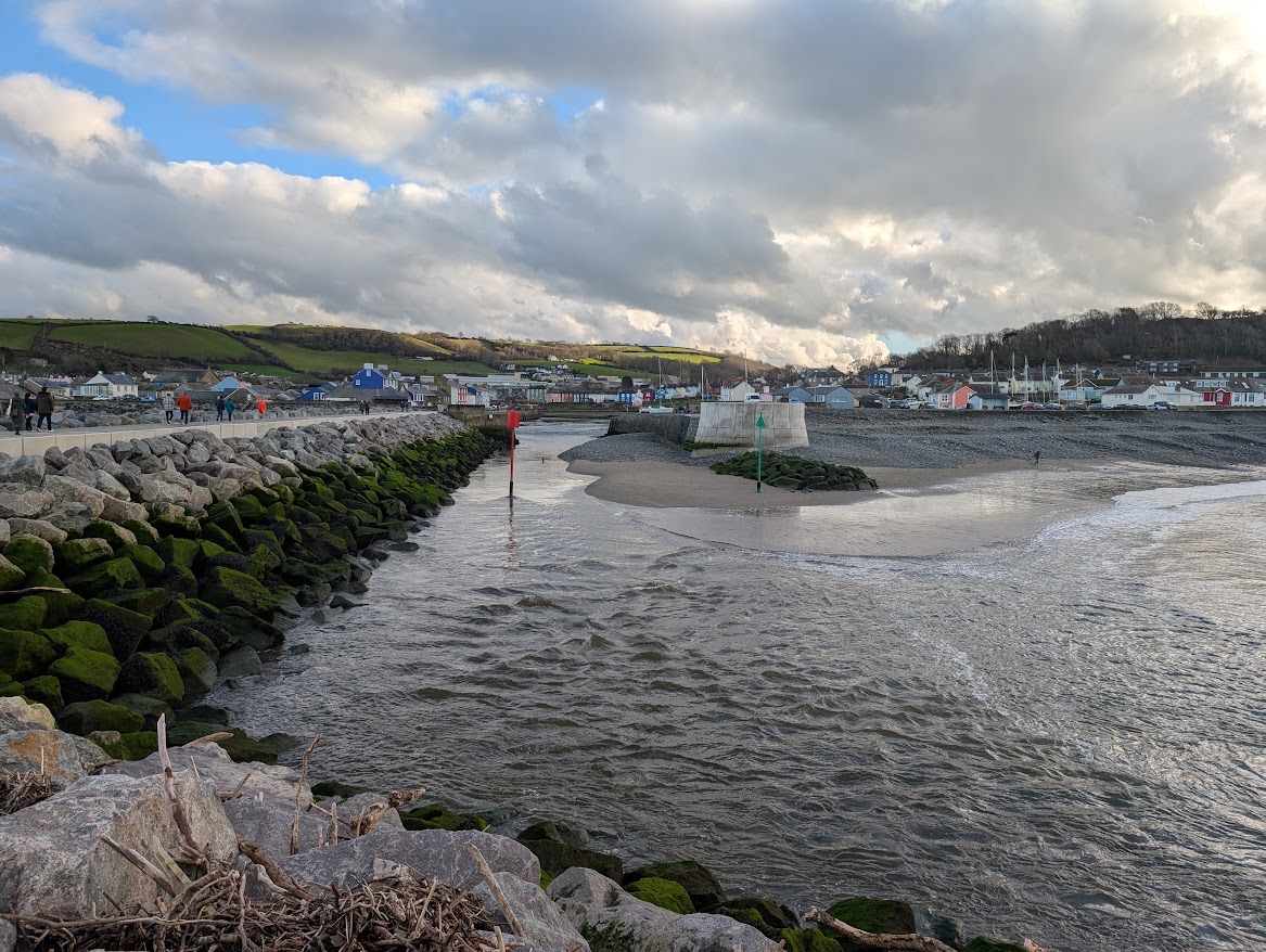
Photo: Aberaeron Harbour entrance viewed from the offshore breakwater in January 2026 by Tally Roberts / CC BY 4.0
These deposits reduced the size of the navigable channel available to boats and, at times, severely restricted access to the harbour. Harbour users raised concerns that vessels were becoming increasingly dependent on a narrow channel that required regular maintenance.
To keep the harbour operational, dredging has been required to remove accumulated sediment and restore access for boats.
An Ongoing Challenge
Following dredging, access to the harbour can be restored and boats can once again use the harbour safely. However, sediment continues to be transported towards the harbour entrance by natural coastal processes.
As a result, sediment gradually builds up again over time, eventually requiring another round of dredging.
Rather than providing a permanent solution, dredging currently manages the symptoms of sediment accumulation. This means that maintaining harbour access has become an ongoing management challenge.
This raises an important question:
Has the flood defence scheme solved one problem while creating another?
Dredging the Harbour
What is Dredging?
Dredging is the process of removing sediment such as sand, silt and shingle from the bottom of a river, harbour or navigation channel.
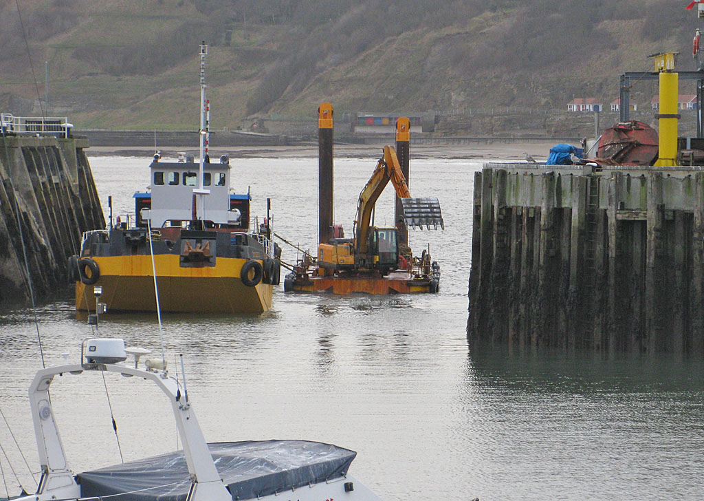
Dredger at work in the harbour entrance, Scarborough © Pauline E / CC BY-SA 2.0.
At Aberaeron, dredging is used to remove sediment that accumulates near the harbour entrance. This helps maintain a navigable channel for boats entering and leaving the harbour.
What Happens to the Dredged Material?
Sediment removed from the harbour entrance is not treated as waste. Instead, the material is moved to South Beach, where it helps replenish the beach and provide protection against coastal erosion.
Supporters argue that this approach makes use of natural sediment and helps maintain the beach.
However, some harbour users question whether relocating the material within the same coastal system simply allows it to be transported back towards the harbour entrance in the future.
Benefits of Dredging
Supports harbour users: A deeper and wider channel makes it easier for fishing vessels, leisure craft and other users to access the harbour safely.
Benefits the local economy: Maintaining harbour access supports businesses linked to the harbour, including tourism, hospitality and marine industries.
Provides material for beach replenishment: The dredged sediment is placed on South Beach, where it can help maintain beach levels and contribute to coastal protection.
Costs and Drawbacks of Dredging
Expensive: Dredging requires specialist equipment, trained operators and ongoing monitoring. This means there are continuing costs for the local authority. Aberaeron harbour entrance dredging was required twice within the first six months after the completion of the sea defences. Each dredging operation cost Ceredigion County Council approximately £15,000 - which at the current rate of demand will easily exceed £60,000 a year.
Not a permanent solution: Sediment continues to move along the coastline, so the material removed by dredging gradually returns. The process therefore needs to be repeated.
Potential environmental impacts: Dredging can disturb seabed habitats and marine organisms. Care is needed to minimise impacts on local ecosystems.
Disruption during dredging operations: The dredging process can temporarily affect harbour activities while work is being carried out.
Questions about long-term sustainability: Some harbour users have questioned whether repeatedly removing sediment from the harbour entrance and relocating it to South Beach addresses the underlying problem, particularly if coastal processes continue to transport material back towards the harbour.
Resolving the Issue
Dredging helps keep Aberaeron Harbour open and usable, but it is expensive and may need to be repeated regularly.
At present, regular dredging forms part of Ceredigion County Council's approach to managing sediment accumulation at the harbour entrance. The harbour and coastal defences will continue to be monitored, with a wider review of the scheme planned for 2050.
This means that, for now, dredging is being used to manage the effects of sediment build-up while longer-term evidence is gathered about how the harbour continues to respond to the flood defence scheme.
Is dredging a long-term solution, or should a different approach be considered in the future?
Different Perspectives
Residents
For many residents, the scheme has been a success. The flood defences reduce the risk of homes being damaged by flooding and coastal erosion, particularly during major storms. This provides reassurance for people living near the waterfront and may also help improve access to flood insurance and mortgage lending by reducing the level of flood risk associated with properties.
Many residents may therefore feel that the benefits of protecting homes outweigh the challenges now faced at the harbour entrance.
Businesses
Many businesses benefit from reduced flood risk. Shops, cafés, restaurants and other local enterprises rely on a safe and attractive town centre. Flooding can lead to expensive repairs, higher insurance costs and lost income, while improved flood protection helps reduce these risks.
However, Aberaeron is also a harbour town. Some local businesses depend directly or indirectly on fishing, boating and visitors who use the harbour. Concerns about harbour access and the need for repeated dredging have led some business owners to question whether the long-term needs of the harbour are being fully met.
As a result, many businesses support the flood defence scheme but may have different opinions about how the harbour should be managed in the future.
Boat Owners and Harbour Users
Many harbour users recognise the importance of protecting Aberaeron from flooding. However, some are concerned that sediment accumulation at the harbour entrance has made access more difficult.
Repeated dredging can restore the navigation channel, but it also creates uncertainty about future harbour access. Some harbour users question whether dredging alone is a sustainable long-term solution.
Concerns have also been raised about relocating dredged material onto South Beach if some of that sediment later returns to the harbour entrance through natural coastal processes.
Ceredigion County Council
The Council's primary objective was to protect Aberaeron from flooding and coastal erosion while preparing the town for future climate change.
From this perspective, the scheme has achieved its main goal by reducing risk to residential properties, businesses and infrastructure.
The Council currently manages the sediment issue through monitoring and dredging, with a review of the overall scheme planned for 2050.
Environment
Natural coastlines are constantly changing. Coastal defences can help protect people and property, but they can also alter the movement of waves and sediment.
Some environmental concerns focus on how engineering structures affect coastal processes and habitats. Dredging may also disturb organisms living on or within the seabed.
At the same time, allowing flooding and erosion to continue unchecked would have its own environmental and social consequences.
You Decide
The Aberaeron Coastal Defence Scheme was designed to reduce the risk of flooding and coastal erosion.
Since its completion in 2025:
-
Flood risk to 168 residential properties has been reduced.
-
Businesses and infrastructure have greater protection from flooding.
-
The town is better prepared for future sea-level rise and climate change.
However:
-
Large amounts of sediment continue to accumulate at the harbour entrance.
-
Dredging is required to maintain access to the harbour.
-
Some harbour users remain concerned about the long-term future of the harbour.
Different people therefore have different opinions about whether the scheme should be considered a success.
Consider the Evidence
Arguments that the scheme has been successful:
- Reduced flood risk to homes and businesses.
- Increased resilience to climate change.
- Protection of important infrastructure.
- Reduced risk of coastal erosion.
- Improved public spaces around the harbour.
Arguments that challenges remain:
- Significant sediment accumulation at the harbour entrance.
- Ongoing dredging costs.
- Concerns about harbour accessibility.
- Uncertainty about the long-term management of sediment.
- A formal review of the scheme is not planned until 2050.
What Do You Think?
-
Has the Aberaeron Coastal Defence Scheme been successful?
-
Which is more important:
- protecting homes and businesses from flooding, or
- maintaining unrestricted harbour access?
-
Is regular dredging an acceptable long-term solution?
-
If you were reviewing the scheme in 2050, would you:
- keep the current approach,
- increase dredging,
- build additional coastal defences,
- or consider a different solution?
Your Conclusion
Use evidence from throughout this case study to explain your answer.